
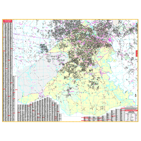
Augusta WALL Map, Georgia, America.
$249.95
In stock
Scale 1:2,484. Size 70" W x 54" H. Laminated. Printed in color on a durable, laminated surface which is both markable and washable. Streets are indexed in a separate book. This area of ranges: (Expanded coverage over the 3rd. edition: West - 2 miles to include Appling and Harlem, 2 miles east to include portions of Jackson) North: includes North Evans & Martinez in Columbia Co, and North Augusta and Burnettown in South Carolina; South: to the Burke County line, including Hephzibah and Blythe; East: 6 1/2 mikes east of the GA State line & 3 1/2 miles east of Radcliff Plantation State Park in SC, including a portion of Jackson; West: includes Harlem, Appling and Grovetown in Columbia County. Special features and data are as follows: all streets and highways, government buildings, airports, golf courses and country clubs, railroads, longitude and latitude lines, ZIP codes and ZIP code boundaries, shopping centers, recreational parks, mileage circles, cemeteries, educational facilities, hospitals, post offices, city limits and annexations, fire and police stations, section/township/range lines, longitude and latitude lines, and miscellaneous points of interest. Framing rails are included on top and bottom for easy wall mounting. Railed wall maps can be turned into pull down maps on spring rollers for an additional $40.
Scale 1:2,484. Size 70" W x 54" H. Laminated. Printed in color on a durable, laminated surface which is both markable and washable. Streets are indexed in a separate book. This area of ranges: (Expanded coverage over the 3rd. edition: West - 2 miles to include Appling and Harlem, 2 miles east to include portions of Jackson) North: includes North Evans & Martinez in Columbia Co, and North Augusta and Burnettown in South Carolina; South: to the Burke County line, including Hephzibah and Blythe; East: 6 1/2 mikes east of the GA State line & 3 1/2 miles east of Radcliff Plantation State Park in SC, including a portion of Jackson; West: includes Harlem, Appling and Grovetown in Columbia County. Special features and data are as follows: all streets and highways, government buildings, airports, golf courses and country clubs, railroads, longitude and latitude lines, ZIP codes and ZIP code boundaries, shopping centers, recreational parks, mileage circles, cemeteries, educational facilities, hospitals, post offices, city limits and annexations, fire and police stations, section/township/range lines, longitude and latitude lines, and miscellaneous points of interest. Framing rails are included on top and bottom for easy wall mounting. Railed wall maps can be turned into pull down maps on spring rollers for an additional $40.
| Item Price | $249.95 + $24.80 p&h (add $40 for spring rollers) |
|---|
Write Your Own Review