
Bartlesville WALL Map, Oklahoma, America.
$249.95
In stock
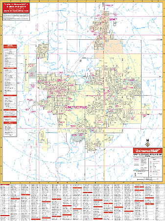
Size 54" W x 40" H. Laminated. The Bartlesville, Oklahoma Wall Map by Universal Map provides up-to-date cartography showing the new streets and changes. Provides street indexing with zip codes, lamination, and measures 4 feet 2 inches by 5 feet 6 inches. Covers north to Dewey and the Washington County softball field; south 2 miles south of Rice Creek Road; east to Bartlesville; and west to Bartlesville Municipal Airport. Shows all streets, post offices, hospitals, railroads, mileage circles, airports, cemeteries, shopping centers, water features, recreational parks, government buildings, fire/police stations, educational facilities, and golf courses/country clubs. Framing rails are included on top and bottom for easy wall mounting. Railed wall maps can be turned into pull down maps on spring rollers for an additional $40.
Size 54" W x 40" H. Laminated. The Bartlesville, Oklahoma Wall Map by Universal Map provides up-to-date cartography showing the new streets and changes. Provides street indexing with zip codes, lamination, and measures 4 feet 2 inches by 5 feet 6 inches. Covers north to Dewey and the Washington County softball field; south 2 miles south of Rice Creek Road; east to Bartlesville; and west to Bartlesville Municipal Airport. Shows all streets, post offices, hospitals, railroads, mileage circles, airports, cemeteries, shopping centers, water features, recreational parks, government buildings, fire/police stations, educational facilities, and golf courses/country clubs. Framing rails are included on top and bottom for easy wall mounting. Railed wall maps can be turned into pull down maps on spring rollers for an additional $40.
| Item Price | $249.95 + $24.80 p&h (add $40 for spring rollers) |
|---|
Write Your Own Review