
Big South Fork National River and Recreation Area, Road and Recreation Map, Tennessee, America.
$17.95
In stock
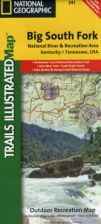
Scale 1:45,000. Size 26"x37". Trails Illustrated edition. Printed on waterproof, tear-resistant, lightweight, paper-like plastic. Big South Fork National River & Recreation Area straddles southern Kentucky and northern Tennessee. This is the most comprehensive guide for hiking, biking, exploring, climbing, camping, and sightseeing in this stunning area. The map includes: Daniel Boone National Forest; Scott State Forest; Cumberland River; Little South Fork; Big South Fork and Clear Fork; New River; Lake Cumberland; Yahoo Falls Scenic Area; Blue Heron Area; Bandy Creek Campground; Leatherwood Ford; Honey Creek; Burnt Mill Bridge; Alum Ford; John Muir Trail; Bear Creek Overlook. Includes UTM grids for use with your GPS.
Scale 1:45,000. Size 26"x37". Trails Illustrated edition. Printed on waterproof, tear-resistant, lightweight, paper-like plastic. Big South Fork National River & Recreation Area straddles southern Kentucky and northern Tennessee. This is the most comprehensive guide for hiking, biking, exploring, climbing, camping, and sightseeing in this stunning area. The map includes: Daniel Boone National Forest; Scott State Forest; Cumberland River; Little South Fork; Big South Fork and Clear Fork; New River; Lake Cumberland; Yahoo Falls Scenic Area; Blue Heron Area; Bandy Creek Campground; Leatherwood Ford; Honey Creek; Burnt Mill Bridge; Alum Ford; John Muir Trail; Bear Creek Overlook. Includes UTM grids for use with your GPS.
| Item Price | $17.95 |
|---|
Write Your Own Review