
Canyons of the Escalante Road and Recreation Map, Utah, America.
$17.95
In stock
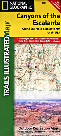
Scale 1:75,000. Size 26"x37". Trails Illustrated edition. Printed on waterproof, tear-resistant, lightweight, paper-like plastic. This Trails Illustrated topographic map is the most comprehensive recreational map for Utah's Canyons of the Escalante area. Coverage includes: BLM - Escalante Resource Area; Dixie National Forest; Glen Canyon National Recreation Area; Box Hollow Wilderness Area; Death Hollow Natural Area and Wolverine Petrified Wood Natural Area; Boulder Town, Escalante and Devils Garden; Fiftymile Bench; Escalante Canyons and surrounding area; Escalante River; northwest Lake Powell.
Scale 1:75,000. Size 26"x37". Trails Illustrated edition. Printed on waterproof, tear-resistant, lightweight, paper-like plastic. This Trails Illustrated topographic map is the most comprehensive recreational map for Utah's Canyons of the Escalante area. Coverage includes: BLM - Escalante Resource Area; Dixie National Forest; Glen Canyon National Recreation Area; Box Hollow Wilderness Area; Death Hollow Natural Area and Wolverine Petrified Wood Natural Area; Boulder Town, Escalante and Devils Garden; Fiftymile Bench; Escalante Canyons and surrounding area; Escalante River; northwest Lake Powell.
| Item Price | $17.95 |
|---|
Write Your Own Review