
Charlotte WALL Map, North Carolina, America.
$249.95
In stock
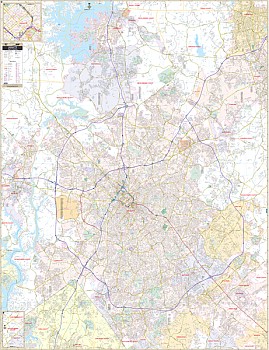
Scale 1:2,640. Size 54" W x 77" H. Laminated. Printed in color with a markable and washable laminated surface. Streets indexed in a separate book. Provided with hanging rails mounted top and bottom. The area of coverage includes all of Mecklenburg County with the following borders: North: To Iredell County Line, including Davidson and Cornelius; South: Tega Cay, Fort Mill, and Weddington; East: Mint Hill, Harrisburg, and portions of Concord; West: Mount Holly and Belmont. There is also an inset of the Downtown Charlotte Area. The special features, data, and details include all city streets and highways, government buildings, ZIP codes and boundaries, airports, golf courses and country clubs, water features, mileage circles, block numbers, post offices, shopping centers, cemeteries, fire districts, fire and police stations, educational facilities, recreational parks, railroads, and city limits and annexations. Railed wall maps can be turned into pull down maps on spring rollers for an additional $40.
Scale 1:2,640. Size 54" W x 77" H. Laminated. Printed in color with a markable and washable laminated surface. Streets indexed in a separate book. Provided with hanging rails mounted top and bottom. The area of coverage includes all of Mecklenburg County with the following borders: North: To Iredell County Line, including Davidson and Cornelius; South: Tega Cay, Fort Mill, and Weddington; East: Mint Hill, Harrisburg, and portions of Concord; West: Mount Holly and Belmont. There is also an inset of the Downtown Charlotte Area. The special features, data, and details include all city streets and highways, government buildings, ZIP codes and boundaries, airports, golf courses and country clubs, water features, mileage circles, block numbers, post offices, shopping centers, cemeteries, fire districts, fire and police stations, educational facilities, recreational parks, railroads, and city limits and annexations. Railed wall maps can be turned into pull down maps on spring rollers for an additional $40.
| Item Price | $249.95 + $24.80 p&h (add $40 for spring rollers) |
|---|
Write Your Own Review