
Chicago Loop WALL Map, Illinois, America.
$229.95
In stock
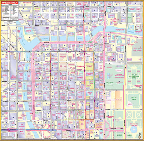
Scale 1:100,000. Size 54" W x 54" H. Laminated. The 3rd edition Chicago, Illinois Loop Wall Map by Universal Map. Printed in color with a markable/washable-laminated surface. Provided with hanging rails mounted top and bottom. The area of coverage ranges: North: to the Chicago River; South: to include Congress Parkway; East: to Columbus Drive; West: to Canal Street. Details include streets and highways, churches, retail buildings, metro lines and stations, museums and parks, government buildings, one-way streets, shopping centers, educational buildings, CTA lines, hospitals, commercial buildings, railroads, water features, and points of interest. Railed wall maps can be turned into pull down maps on spring rollers for an additional $40.
Scale 1:100,000. Size 54" W x 54" H. Laminated. The 3rd edition Chicago, Illinois Loop Wall Map by Universal Map. Printed in color with a markable/washable-laminated surface. Provided with hanging rails mounted top and bottom. The area of coverage ranges: North: to the Chicago River; South: to include Congress Parkway; East: to Columbus Drive; West: to Canal Street. Details include streets and highways, churches, retail buildings, metro lines and stations, museums and parks, government buildings, one-way streets, shopping centers, educational buildings, CTA lines, hospitals, commercial buildings, railroads, water features, and points of interest. Railed wall maps can be turned into pull down maps on spring rollers for an additional $40.
| Item Price | $229.95 + $24.80 p&h (add $40 for spring rollers) |
|---|
Write Your Own Review