
Cincinnati and Dayton Vicinity WALL Map, Ohio, America.
$249.95
In stock
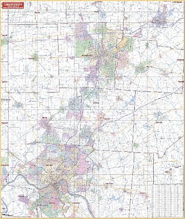
Scale 1:125,000. Size 54" W x 64" H. Laminated. The 1st edition Wall Map of Cincinnati and Dayton, Ohio and vicinity and surrounding 13 counties by Universal Map. Printed in color with a markable and washable laminated surface with hanging rails mounted on top and bottom. Cities are indexed on the face of the map. Area of coverage includes all of the counties of Butler, Clermont, Greene, Hamilton, Montgomery, Preble, and Warren; portions of Brown, Clark, Clinton, Darke, Highland, and Miami Counties with the following boundaries: North: including Tipp City in Miami County, and Springfield and Nothridge in Clark County; South: including Boone, Kenton, and Campbell Counties in Kentucky; East: including New Vienna in Clinton County; West: to the Indiana State line. Details include major streets and all highways, county lines and names, mileage circles, ZIP codes and boundaries, airports and parks, water features, and longitude/latitude lines. Railed wall maps can be turned into pull down maps on spring rollers for an additional $40.
Scale 1:125,000. Size 54" W x 64" H. Laminated. The 1st edition Wall Map of Cincinnati and Dayton, Ohio and vicinity and surrounding 13 counties by Universal Map. Printed in color with a markable and washable laminated surface with hanging rails mounted on top and bottom. Cities are indexed on the face of the map. Area of coverage includes all of the counties of Butler, Clermont, Greene, Hamilton, Montgomery, Preble, and Warren; portions of Brown, Clark, Clinton, Darke, Highland, and Miami Counties with the following boundaries: North: including Tipp City in Miami County, and Springfield and Nothridge in Clark County; South: including Boone, Kenton, and Campbell Counties in Kentucky; East: including New Vienna in Clinton County; West: to the Indiana State line. Details include major streets and all highways, county lines and names, mileage circles, ZIP codes and boundaries, airports and parks, water features, and longitude/latitude lines. Railed wall maps can be turned into pull down maps on spring rollers for an additional $40.
| Item Price | $249.95 + $24.80 p&h (add $40 for spring rollers) |
|---|
Write Your Own Review