
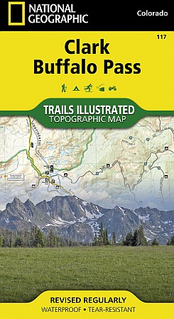
Clark and Buffalo Pass Area.
$17.95
In stock
Scale 1:41,000. Size 22"x32". The Clark/Buffalo Pass Trails Illustrated map is the most comprehensive recreational map for this beautiful area in northern Colorado. Coverage includes Routt National Forest, Mt Zirkel Wilderness, Spring Creek Mountain Park, and Park Range. Also includes the city of Clark; Glen Eden and Mad creeks; Rainbow, Fish Hawk, Hidden, Roxy Ann and Red Canyon lakes; the Elk River; and Buffalo Pass. The map also includes coverage of the Continental Divide Trail as it winds through Mount Zirkel Wilderness and Routt National Forest.
Scale 1:41,000. Size 22"x32". The Clark/Buffalo Pass Trails Illustrated map is the most comprehensive recreational map for this beautiful area in northern Colorado. Coverage includes Routt National Forest, Mt Zirkel Wilderness, Spring Creek Mountain Park, and Park Range. Also includes the city of Clark; Glen Eden and Mad creeks; Rainbow, Fish Hawk, Hidden, Roxy Ann and Red Canyon lakes; the Elk River; and Buffalo Pass. The map also includes coverage of the Continental Divide Trail as it winds through Mount Zirkel Wilderness and Routt National Forest.
| Item Price | $17.95 |
|---|
Write Your Own Review