
Cobb County WALL Map, Georgia, America.
$249.95
In stock
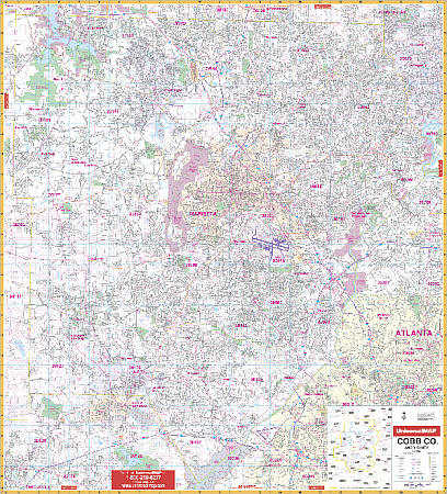
Scale 1:2,000. Size 54" W x 61" H. Laminated. Includes a laminated surface making the wall map markable and washable, along with street indexing in a separate book. The area of coverage includes the following: Cobb County and adjacent area including Austell, Blackwells, Bolton, Clarksdale, Elizabeth, Fair Oaks, East Marietta, Floyd, Kennesaw, Marbleton, Marietta, Noonday, Powder Springs, Smyrna, South Cobb, Vinings, and Westoak; Lithia Springs and portion of Douglasville in Douglas County; approximately 2-4 miles into Atlanta, including I-75 and I-85 in Fulton County; North to the Cherokee County Line; South to the Fulton/Douglas County line; East to the Fulton County line; West to the Paulding County line. Details and information includes: all streets, all highways, educational facilities, post offices, government buildings, fire and police stations, hospitals, shopping centers, land lot numbers, airports, cemeteries, railroads, water features, golf courses and country clubs, mileage circles, recreational parks, ZIP codes and boundaries, city limits and annexations, and other miscellaneous points of interest. Railed wall maps can be turned into pull down maps on spring rollers for an additional $40.
Scale 1:2,000. Size 54" W x 61" H. Laminated. Includes a laminated surface making the wall map markable and washable, along with street indexing in a separate book. The area of coverage includes the following: Cobb County and adjacent area including Austell, Blackwells, Bolton, Clarksdale, Elizabeth, Fair Oaks, East Marietta, Floyd, Kennesaw, Marbleton, Marietta, Noonday, Powder Springs, Smyrna, South Cobb, Vinings, and Westoak; Lithia Springs and portion of Douglasville in Douglas County; approximately 2-4 miles into Atlanta, including I-75 and I-85 in Fulton County; North to the Cherokee County Line; South to the Fulton/Douglas County line; East to the Fulton County line; West to the Paulding County line. Details and information includes: all streets, all highways, educational facilities, post offices, government buildings, fire and police stations, hospitals, shopping centers, land lot numbers, airports, cemeteries, railroads, water features, golf courses and country clubs, mileage circles, recreational parks, ZIP codes and boundaries, city limits and annexations, and other miscellaneous points of interest. Railed wall maps can be turned into pull down maps on spring rollers for an additional $40.
| Item Price | $249.95 + $24.80 p&h (add $40 for spring rollers) |
|---|
Write Your Own Review