
Des Moines WALL Map.
$249.95
In stock
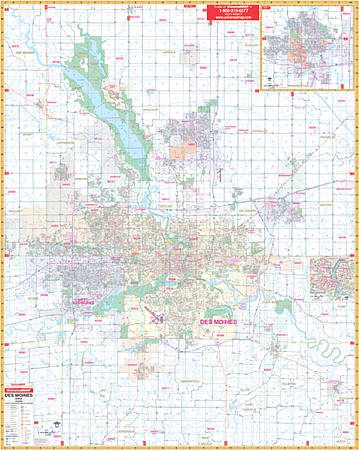
Scale 1:2,600. Size 54" W x 69" H. Laminated. Printed in color with a markable/washable-laminated surface. Streets are indexed in a separate book. The Area of coverage: includes all of Des Moines with the following boundaries: North: to the Polk/Boone County lines; South: to the village of Spring Hill--5 miles south of Norwalk; East: to the village of Hartford, Altoona, and Bondurant; West: to the city of Waukee. Insets: city of Ames and downtown Des Moines. Special features, data, and details covers all streets and highways, government buildings, airports, golf courses and country clubs, railroads, longitude and latitude lines, block numbers, shopping centers, recreation parks, mileage circles, cemeteries, educational facilities, hospitals, post offices, city limits and annexations, block numbers, longitude and latitude lines, section/township/and range numbers, water features, fire and police stations, fire district lines, ZIP codes and boundaries, mileage circles, and assorted points of interest. Framing rails are included on top and bottom for easy wall mounting. Railed wall maps can be turned into pull down maps on spring rollers for an additional $40.
Scale 1:2,600. Size 54" W x 69" H. Laminated. Printed in color with a markable/washable-laminated surface. Streets are indexed in a separate book. The Area of coverage: includes all of Des Moines with the following boundaries: North: to the Polk/Boone County lines; South: to the village of Spring Hill--5 miles south of Norwalk; East: to the village of Hartford, Altoona, and Bondurant; West: to the city of Waukee. Insets: city of Ames and downtown Des Moines. Special features, data, and details covers all streets and highways, government buildings, airports, golf courses and country clubs, railroads, longitude and latitude lines, block numbers, shopping centers, recreation parks, mileage circles, cemeteries, educational facilities, hospitals, post offices, city limits and annexations, block numbers, longitude and latitude lines, section/township/and range numbers, water features, fire and police stations, fire district lines, ZIP codes and boundaries, mileage circles, and assorted points of interest. Framing rails are included on top and bottom for easy wall mounting. Railed wall maps can be turned into pull down maps on spring rollers for an additional $40.
| Item Price | $249.95 + $24.80 p&h (add $40 for spring rollers) |
|---|
Write Your Own Review