
Europe Primary "Classroom" WALL Map On Roller with Back Board.
$179.95
In stock
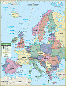
Size 54"x64". Universal Map edition. Laminated. This Primary Classroom Wall Map of Europe by Universal Map features color-coded countries and measure 54" W x 69" H. The laminated surface makes it both markable and washable. There is an inset map of the world showing the relative position of Europe. The area of coverage runs: North: to Greenland and Denmark Strait; South: to the Mediterranean; East: to Russia and Turkey; West: to the North Atlantic Ocean. Details included with this map are national capitals, national boundaries, the Prime Meridian (Greenwich), cities, mountain peaks, and latitude and longitude lines. Mounted on roller with backboard. This product is ideal for public, private, parochial, and home schools.
Size 54"x64". Universal Map edition. Laminated. This Primary Classroom Wall Map of Europe by Universal Map features color-coded countries and measure 54" W x 69" H. The laminated surface makes it both markable and washable. There is an inset map of the world showing the relative position of Europe. The area of coverage runs: North: to Greenland and Denmark Strait; South: to the Mediterranean; East: to Russia and Turkey; West: to the North Atlantic Ocean. Details included with this map are national capitals, national boundaries, the Prime Meridian (Greenwich), cities, mountain peaks, and latitude and longitude lines. Mounted on roller with backboard. This product is ideal for public, private, parochial, and home schools.
| Item Price | $179.95 Rolled + $24.80 p&h |
|---|
Write Your Own Review