
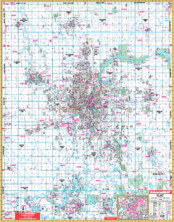
Flint WALL Map.
$249.95
In stock
Scale 1:2,480. Size 54" W x 70" H. Laminated. The 5th edition Flint, Genesee County, Michigan Wall Map by Universal Map. Printed in color with a laminated surface that is both markable and washable. Included is all of Genesee County with the following boundaries: North: to the Saginaw-Tuscola County lines; South: to the Livingston-Oakland County lines including Holly in Oakland County; East: to the Lapeer County line; West: to the Shiawassee County line. There is also an inset map of Downtown Flint. The special features and data are as follows: all streets and highways, government buildings, airports, golf courses and country clubs, railroads, ZIP codes and ZIP code boundaries, shopping centers, water features, recreational parks, cemeteries, educational facilities, hospitals, post offices, city limits and annexations, section/township/range lines, block numbers, mileage circles, fire and police stations, and miscellaneous points of interest. Framing rails are included on top and bottom for easy wall mounting. Railed wall maps can be turned into pull down maps on spring rollers for an additional $40.
Scale 1:2,480. Size 54" W x 70" H. Laminated. The 5th edition Flint, Genesee County, Michigan Wall Map by Universal Map. Printed in color with a laminated surface that is both markable and washable. Included is all of Genesee County with the following boundaries: North: to the Saginaw-Tuscola County lines; South: to the Livingston-Oakland County lines including Holly in Oakland County; East: to the Lapeer County line; West: to the Shiawassee County line. There is also an inset map of Downtown Flint. The special features and data are as follows: all streets and highways, government buildings, airports, golf courses and country clubs, railroads, ZIP codes and ZIP code boundaries, shopping centers, water features, recreational parks, cemeteries, educational facilities, hospitals, post offices, city limits and annexations, section/township/range lines, block numbers, mileage circles, fire and police stations, and miscellaneous points of interest. Framing rails are included on top and bottom for easy wall mounting. Railed wall maps can be turned into pull down maps on spring rollers for an additional $40.
| Item Price | $249.95 + $24.80 p&h (add $40 for spring rollers) |
|---|
Write Your Own Review