
Israel Road and Physical Tourist Map, including Nature Reserves and National Parks.
$14.95
In stock
Scale 1:270,000. Size 30"x30" (approximately). Printed on both sides. Indexed. Carta edition. Elevations and topographic features are shown by hypsometric color tints. This is a terrific large-scale map which includes all towns and villages (more than 3,500 sites), roads, road classifications, and road numbers, with interchanges and junctions highlighted; Nature Reserves, National Parks, details of all available facilities, Israel Walking Trail from Dan to Eilat, altitudes, springs and water reservoirs, along with a booklet of color photos and descriptions of Reserves and Parks. English text and legends.
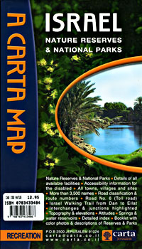
Scale 1:270,000. Size 30"x30" (approximately). Printed on both sides. Indexed. Carta edition. Elevations and topographic features are shown by hypsometric color tints. This is a terrific large-scale map which includes all towns and villages (more than 3,500 sites), roads, road classifications, and road numbers, with interchanges and junctions highlighted; Nature Reserves, National Parks, details of all available facilities, Israel Walking Trail from Dan to Eilat, altitudes, springs and water reservoirs, along with a booklet of color photos and descriptions of Reserves and Parks. English text and legends.
| Item Price | $14.95 |
|---|
Write Your Own Review