
Andorra Road Maps | Detailed Travel Tourist Driving
Andorra - A New Map of the Oldest Country in the World
Andorra is often called ’The Poor Man’s Switzerland’. It is the safest and the sixth smallest European country located between France and Spain. The sovereign landlocked mini-country has the best ski slopes and the convenience resorts in the Pyrenees mountains.
Principality of Andorra is the biggest among the group of diminutive states in Europe, comprising of Liechtenstein, Monaco and San-Marino with an area of 468 square kilometers. Its capital, Andorra la Vella is at an altitude of 1013m above sea level, the highest capital in Europe. The country is divided into 7 administrative districts.
About 30% of the country’s land area are a national parkunder UNESCO. The beautiful landscapes, thermal springs, low crime rate, relatively low cost of living compared to the neighboring countries, France and Spain fascinate 10 million tourists every year.
Enjoy duty free shopping in the capital with Europe’s lowest VAT of 4.5%, Andorra la Vella, get-away hike, a Mediterranean lunch or a spa. You can revel in the scenic drive through the Pyrenees, hear just water and wind and breathe in all the reservoirs, castles, Roman architecture on small churches and bridges.
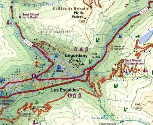
If you are ready to go and get to the heart of Andorra, take a map along so you can enjoy everything Andorra has to offer in just one day. Some of the other important cities worth a visit are Escaldes-Engordany, Encamp, Sant Julià de Lòria, Arinsal, Pal, Ordino, Canillo and Soldeu. Escaldes-Engordany is famous for its hot springs and Santa Anna dance.
Though Andorra has no international airport, there are roads to the neighboring countries of Spain and France. It takes just three hours to get to the airports of Barcelona and Toulouse. You can choose to travel by road to Paris in about 10 hours and 8 hours to Madrid.
Andorra Road Maps for Tourists and TravelersDetailed Road Map of AndorraBuy travel maps for Andorra tourist attractions, road trips, street guide, driving directions and more |
Andorra
- $17.95
Item Code : ITMB4878
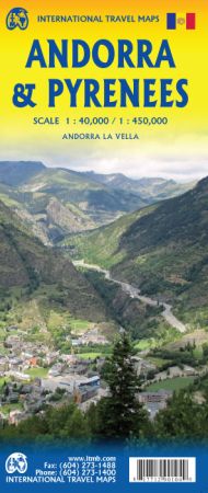
Scale 1:40,000 / 1:450,000. Size 27"x39". International Travel Map edition.
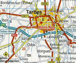
We have transformed our specialized map of Andorra into a more practical map covering the Pyrenees mountain chain straddling the border between France and Spain on one side, with historic Andorra on other side.
It is combining two areas at different scales, the map has two covers, so can be marketed equally well as Andorra or as Pyrenees. Our coverage of Pyrenees goes from the Atlantic to the Mediterranean coastlines and from Toulouse to Barcelona, so includes Pamplona in basque Country, Huesca, Catalunya, and Girona in Spain, as well as Beziers and lovely Carcassonne in France. The other side is a completely redesigned map of the Principality of Andorra and is the only map of this interesting mini-state available today.
This side also includes an excellent inset map of the only city in the country, Andorra La Vella. Andorra is known as a winter ski area par excellence, but it also a huge duty-free area year round, It has survived political turmoil for centuries by playing off France against Spain and wriggling between the cracks of big-power maneuvering. Perched at the summit of the Pyrenees chain, Andorra is well worth visiting.
- $14.95
Item Code : EAND4879
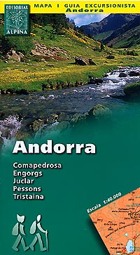
 Scale 1:40,000. Includes a 32-page guide booklet. Spanish text.
 - $19.95
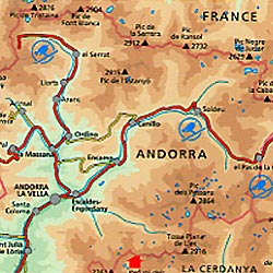
Item Code : REIS4880
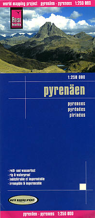
 Scale 1:250,000. Size 27"x39". Reis Know How edition. Very detailed Pyrenees road map. English and multi-lingual legends. Printed on tear-resistant, waterproof, paper-like plastic. It can bend and fold without cracking and is writable as normal paper, non-toxic and recyclable. Perfect for tourist adventures and independent travel and for driving tours. Includes topographic contour lines and hypsometric color tints which show height levels, along with elevation numbers. Shows all major and secondary roads and tertiary roads, with distances between points in kilometers. Fully indexed. Beautiful cartography.
| Postage and handling is $4.40 for the first map and $1.80 for each additional map. ~ ~ ~ ~ ~ ~ Foreign delivery is $15.80 for the first map and $7.60 for each additional map. ~ ~ ~ ~ ~ ~ Canada delivery is $15.80 for the first map and $7.60 for each additional map. |
Andorra - A New Map of the Oldest Country in the World
Andorra is often called ’The Poor Man’s Switzerland’. It is the safest and the sixth smallest European country located between France and Spain. The sovereign landlocked mini-country has the best ski slopes and the convenience resorts in the Pyrenees mountains.
Principality of Andorra is the biggest among the group of diminutive states in Europe, comprising of Liechtenstein, Monaco and San-Marino with an area of 468 square kilometers. Its capital, Andorra la Vella is at an altitude of 1013m above sea level, the highest capital in Europe. The country is divided into 7 administrative districts.
About 30% of the country’s land area are a national parkunder UNESCO. The beautiful landscapes, thermal springs, low crime rate, relatively low cost of living compared to the neighboring countries, France and Spain fascinate 10 million tourists every year.
Enjoy duty free shopping in the capital with Europe’s lowest VAT of 4.5%, Andorra la Vella, get-away hike, a Mediterranean lunch or a spa. You can revel in the scenic drive through the Pyrenees, hear just water and wind and breathe in all the reservoirs, castles, Roman architecture on small churches and bridges.
If you are ready to go and get to the heart of Andorra, take a map along so you can enjoy everything Andorra has to offer in just one day. Some of the other important cities worth a visit are Escaldes-Engordany, Encamp, Sant Julià de Lòria, Arinsal, Pal, Ordino, Canillo and Soldeu. Escaldes-Engordany is famous for its hot springs and Santa Anna dance.
Though Andorra has no international airport, there are roads to the neighboring countries of Spain and France. It takes just three hours to get to the airports of Barcelona and Toulouse. You can choose to travel by road to Paris in about 10 hours and 8 hours to Madrid.
Andorra Road Maps for Tourists and TravelersDetailed Road Map of AndorraBuy travel maps for Andorra tourist attractions, road trips, street guide, driving directions and more |
