
Aruba Road Maps | Detailed Travel Tourist Driving
Discover One Happy Island – Aruba with Our Maps
Even though Aruba is a tiny islet, but its reputation is huge. The island is marketed by the tourism board as ‘one happy island’ — nevertheless what induces this 33.79-kilometer long island close to the shoreline of Venezuela towards the south of the Caribbean island such a tourist pull?
Without an iota of doubt, Aruba Island is home to stunning white-sand shorelines, 82o days, as well as a few of the sincere people on the planet.
The island is positioned barely beneath the hurricane belt, and not like several islands in the Caribbean, the weather is dry.
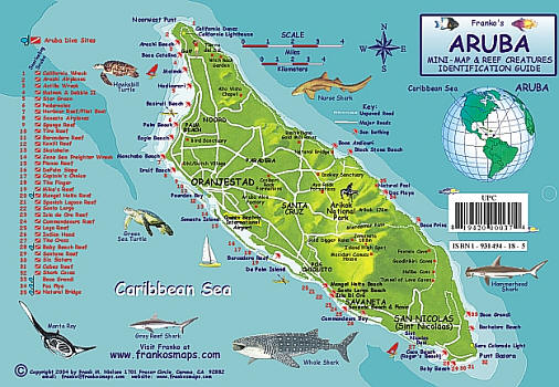
Oranjestad the capital city lies on the south plus west shores of Aruba and you can find miles and miles of beaches which are named as some of the most excellent on the earth. Here, you will discover quite a lot of hotels and all-encompassing holiday resort plus the Queen Beatrix International Airport.
Towards the interior of the islet, you can see the Arikok National Park, a barren region which preserves a multiplicity of animals, cacti as well as vivid rock arrangements. The ocean crashing against the rugged beaches below is a view that is very striking to the eyes.
The island’s informal mascots – the fofoti trees which are gracefully bent forms due to the continuous trade winds, can be seen all along the windward shore on the northeast coast.
Aruba map
So irrespective of the fact you are yearning to sprawl on a beach or to explore into the immense outdoors, Aruba has everything for you. One happy islet, undeniably to venture on your own or with your partner and bask away in the sun happily. You can do more on this island with the help of our maps. Our Aruba maps are very informative and interesting which guides and guides you through the island.
Aruba Road Maps for Tourists and TravelersDetailed Road Map of ArubaBuy travel maps for Aruba tourist attractions, road trips, street guide, driving directions and more |
Aruba
- $17.95
Item Code : BORC5091
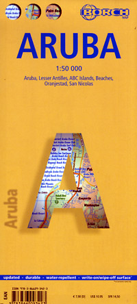
 Scale 1:50,000. Size 19?"x26". Indexed. Borch edition. Printed on both sides. English and multi-lingual legends. Laminated, waterproof, easy-fold, flexi-map. Shows all types of roads, road numbers, distances between points in kilometers, airports, lighthouses, harbors, beaches, information centers, post offices, police stations, monuments, libraries, windmills, caves, tennis courts, golf courses, points of interest, archeological sites, scuba diving sites, yachting areas, windsurfing areas, shipwrecks, snorkeling sites, national parks, nature preserves, altitudes in meters, petrol stations, consulates, view points, churches, museums, rent-a-car agencies, hospitals, department stores, hotels, and more. English and multilingual text. Includes inset indexed city street plans of Oranjestad at 1:10,000 scale, and San Nicolas at 1:20,000 scale, plus the beach cities of Palm Beach and Eagle Beach at 1:25,000 scale. Laminated, easy-fold, flexi-map. Excellent map! BIG >> SAMPLE MAP << Small Sample Map
 - $10.95
Item Code : FRKO5092
 Size 6"x9". Laminated.
| Postage and handling is $4.40 for the first map and $1.80 for each additional map. ~ ~ ~ ~ ~ ~ Foreign delivery is $15.80 for the first map and $7.60 for each additional map. ~ ~ ~ ~ ~ ~ Canada delivery is $15.80 for the first map and $7.60 for each additional map. |
Discover One Happy Island – Aruba with Our Maps
Even though Aruba is a tiny islet, but its reputation is huge. The island is marketed by the tourism board as ‘one happy island’ — nevertheless what induces this 33.79-kilometer long island close to the shoreline of Venezuela towards the south of the Caribbean island such a tourist pull?
Without an iota of doubt, Aruba Island is home to stunning white-sand shorelines, 82o days, as well as a few of the sincere people on the planet.
The island is positioned barely beneath the hurricane belt, and not like several islands in the Caribbean, the weather is dry.
Oranjestad the capital city lies on the south plus west shores of Aruba and you can find miles and miles of beaches which are named as some of the most excellent on the earth. Here, you will discover quite a lot of hotels and all-encompassing holiday resort plus the Queen Beatrix International Airport.
Towards the interior of the islet, you can see the Arikok National Park, a barren region which preserves a multiplicity of animals, cacti as well as vivid rock arrangements. The ocean crashing against the rugged beaches below is a view that is very striking to the eyes.
The island’s informal mascots – the fofoti trees which are gracefully bent forms due to the continuous trade winds, can be seen all along the windward shore on the northeast coast.
Aruba map
So irrespective of the fact you are yearning to sprawl on a beach or to explore into the immense outdoors, Aruba has everything for you. One happy islet, undeniably to venture on your own or with your partner and bask away in the sun happily. You can do more on this island with the help of our maps. Our Aruba maps are very informative and interesting which guides and guides you through the island.
Aruba Road Maps for Tourists and TravelersDetailed Road Map of ArubaBuy travel maps for Aruba tourist attractions, road trips, street guide, driving directions and more |
