
Port Charlotte WALL Map, Florida, America.
$229.95
In stock
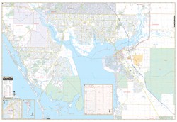
Scale 1:2,280. Size 74"x 54". Laminated. The area of coverage includes all of western Charlotte County with the following boundaries: North: to include Northport and Venice in Sarasota County; South: includes Placida, intersection of CR 775 and 771, and Boca Grande Causeway; East: to US Route 17, including Peace River Shores, Ridge Harbor and Cecil M. Webb Wildlife including Tropical Gulf Acres; West: to the Gulf of Mexico. Insets: Charlotte County, and Burnt Store, Gasparilla Island in Lee County Balance of Eastern Charlotte County at a reduced scale. Details include all streets, post offices, hospitals, railroads, mileage circles, airports, cemeteries, shopping centers, water features, recreational parks, government buildings, fire and police stations, educational facilities, mobile home parks, longitude and latitude lines, range/township/section lines, city limits/annexations, golf courses and country clubs, and ZIP code numbers/boundaries. Framing rails are included on top and bottom for easy wall mounting. Railed wall maps can be turned into pull down maps as a $40 option.
Scale 1:2,280. Size 74"x 54". Laminated. The area of coverage includes all of western Charlotte County with the following boundaries: North: to include Northport and Venice in Sarasota County; South: includes Placida, intersection of CR 775 and 771, and Boca Grande Causeway; East: to US Route 17, including Peace River Shores, Ridge Harbor and Cecil M. Webb Wildlife including Tropical Gulf Acres; West: to the Gulf of Mexico. Insets: Charlotte County, and Burnt Store, Gasparilla Island in Lee County Balance of Eastern Charlotte County at a reduced scale. Details include all streets, post offices, hospitals, railroads, mileage circles, airports, cemeteries, shopping centers, water features, recreational parks, government buildings, fire and police stations, educational facilities, mobile home parks, longitude and latitude lines, range/township/section lines, city limits/annexations, golf courses and country clubs, and ZIP code numbers/boundaries. Framing rails are included on top and bottom for easy wall mounting. Railed wall maps can be turned into pull down maps as a $40 option.
| Item Price | $229.95 + $24.80 p&h (add $40 for spring rollers) |
|---|
Write Your Own Review