
Evansville WALL Map, America.
$249.95
In stock
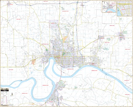
Scale 1:2,400. Size 72" W x 64" H. Laminated. The Evansville, Indiana is the 4th edition Wall Map by Voyager Maps. Provides up-to-date cartography with new streets and changes. Printed in color with a markable/washable-laminated surface. Fitted with hanging rails mounted top and bottom. Streets are indexed in a separate book. Area of coverage: Evansville, Henderson, KY, Boonville, Mt. Vernon, Newburgh, Chandler, Darnmastadt, Poseyville, Eiberfeld, Daylight, McCuthchanville, Stevenson, Cypress, Vaughan, Belknap, Kasson, St. Joseph, and Armstrong. Boundaries: North: to the Vanderburgh/Gibson County line, including Elberfeld in Warrick County; South: including all the city of Henderson in Henderson County; East: including Booneville in Warrick County; West: 4 ? miles west of Vanderburgh/Posey County line, including Poseyville. Inset: Downtown Evansville; Mt. Vernon; Gibson county inset with town of Princeton. Details airports, cemeteries, hospitals, railroads, post offices, longitude/latitude lines, all streets/highways, shopping centers, water features, recreational parks, mileage circles, school district lines, government buildings, fire/police stations, educational facilities, golf courses/country clubs, ZIP codes/boundaries, city limits and annexations, and more. Railed wall maps can be turned into pull down maps on spring rollers for an additional $40.
Scale 1:2,400. Size 72" W x 64" H. Laminated. The Evansville, Indiana is the 4th edition Wall Map by Voyager Maps. Provides up-to-date cartography with new streets and changes. Printed in color with a markable/washable-laminated surface. Fitted with hanging rails mounted top and bottom. Streets are indexed in a separate book. Area of coverage: Evansville, Henderson, KY, Boonville, Mt. Vernon, Newburgh, Chandler, Darnmastadt, Poseyville, Eiberfeld, Daylight, McCuthchanville, Stevenson, Cypress, Vaughan, Belknap, Kasson, St. Joseph, and Armstrong. Boundaries: North: to the Vanderburgh/Gibson County line, including Elberfeld in Warrick County; South: including all the city of Henderson in Henderson County; East: including Booneville in Warrick County; West: 4 ? miles west of Vanderburgh/Posey County line, including Poseyville. Inset: Downtown Evansville; Mt. Vernon; Gibson county inset with town of Princeton. Details airports, cemeteries, hospitals, railroads, post offices, longitude/latitude lines, all streets/highways, shopping centers, water features, recreational parks, mileage circles, school district lines, government buildings, fire/police stations, educational facilities, golf courses/country clubs, ZIP codes/boundaries, city limits and annexations, and more. Railed wall maps can be turned into pull down maps on spring rollers for an additional $40.
| Item Price | $249.95 + $24.80 p&h (add $40 for spring rollers) |
|---|
Write Your Own Review