
Baton Rouge Vicinity WALL Map, Louisiana, America.
$249.95
In stock
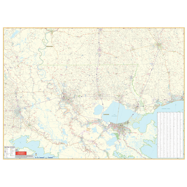
Scale 1:290,000. Size 72" W x 54" H. Laminated. The 2nd edition Baton Rouge Vicinity, Louisiana Wall Map by Universal Map. Printed in color with a markable/washable-laminated surface. Cities indexed on the map's face. Includes hanging rails mounted top and bottom. Area of Coverage: the Gulf of Mexico coastal area from Mobile, Alabama to New Orleans, Louisiana with the following boundaries: North: 70 miles to Brookhave, MS; South East: 85 miles to New Orleans; East:130 miles to include Gulfport and Biloxi, MS; West: 70 miles to include Lafayette. Details include all highways/interstates, mileage circles, ZIP codes/boundaries, airports, longitude/latitude lines, water features, city limits/annexations, and state parks. Railed wall maps can be turned into pull down maps on spring rollers for an additional $40.
Scale 1:290,000. Size 72" W x 54" H. Laminated. The 2nd edition Baton Rouge Vicinity, Louisiana Wall Map by Universal Map. Printed in color with a markable/washable-laminated surface. Cities indexed on the map's face. Includes hanging rails mounted top and bottom. Area of Coverage: the Gulf of Mexico coastal area from Mobile, Alabama to New Orleans, Louisiana with the following boundaries: North: 70 miles to Brookhave, MS; South East: 85 miles to New Orleans; East:130 miles to include Gulfport and Biloxi, MS; West: 70 miles to include Lafayette. Details include all highways/interstates, mileage circles, ZIP codes/boundaries, airports, longitude/latitude lines, water features, city limits/annexations, and state parks. Railed wall maps can be turned into pull down maps on spring rollers for an additional $40.
| Item Price | $249.95 + $24.80 p&h (add $40 for spring rollers) |
|---|
Write Your Own Review