
Ocean County WALL Map, New Jersey, America.
$249.95
In stock
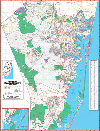
Scale 1:3,588. Size 54" W x 70" H. Laminated. Printed in color with a markable & washable, laminated surface. Provides separate book indexing. Includes hanging rails mounted top and bottom. The area of coverage includes all of Ocean County, with the following boundaries: North: to Monmouth/Ocean County line; South: Great Bay; East: to the Atlantic Ocean; West: to the Burlington/Ocean County line. Details include airports, streets & highways, government buildings, cemeteries, shopping centers, fire & police stations, hospitals, educational facilities, railroads, recreational parks, golf & country clubs, post offices, mileage circles, city limits & annexations, ZIP codes, longitude & latitude lines, and points of interest. Railed wall maps can be turned into pull down maps on spring rollers for an additional $40.
Scale 1:3,588. Size 54" W x 70" H. Laminated. Printed in color with a markable & washable, laminated surface. Provides separate book indexing. Includes hanging rails mounted top and bottom. The area of coverage includes all of Ocean County, with the following boundaries: North: to Monmouth/Ocean County line; South: Great Bay; East: to the Atlantic Ocean; West: to the Burlington/Ocean County line. Details include airports, streets & highways, government buildings, cemeteries, shopping centers, fire & police stations, hospitals, educational facilities, railroads, recreational parks, golf & country clubs, post offices, mileage circles, city limits & annexations, ZIP codes, longitude & latitude lines, and points of interest. Railed wall maps can be turned into pull down maps on spring rollers for an additional $40.
| Item Price | $249.95 + $24.80 p&h (add $40 for spring rollers) |
|---|
Write Your Own Review