
Pickens WALL Map, South Carolina, America.
$249.95
In stock
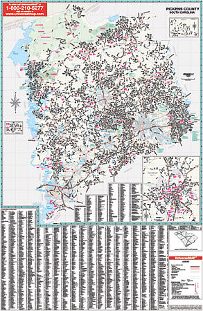
Scale 1:3,708. Size 68" W x 54" H. Laminated. The 3rd Edition Railed Pickens County, South Carolina Wall Map is published by Universal Map. Provides up-to-date cartography with new streets and changes. Printed in color with a markable and washable laminated surface. Streets are indexed on the face of the map. Hanging rails mounted top and bottom. Railed wall maps can be turned into pull down maps on spring rollers for an additional $40. Area of coverage: Section I: All of Pickens County at a scale of 1" = 3,708 feet with the following boundaries: North: to the Greenville County & North Carolina State line; South: to the Pickens/Anderson County line; East: to the Pickens/Greenville County line; West: to the Pickens/Oconee County line. Section II Scale approximately 1" = 2,600 feet. Insets of the following cities: Central, Clemson, Easley, Liberty, Norris, Pickens, and Six Mile. Includes all streets and highways, government buildings, airports, water features, fire/police stations, hospitals, shopping centers, educational facilities, railroads, recreational parks, golf & country clubs, post offices, city limits & annexations, cemeteries, ZIP codes, and points of interest.
Scale 1:3,708. Size 68" W x 54" H. Laminated. The 3rd Edition Railed Pickens County, South Carolina Wall Map is published by Universal Map. Provides up-to-date cartography with new streets and changes. Printed in color with a markable and washable laminated surface. Streets are indexed on the face of the map. Hanging rails mounted top and bottom. Railed wall maps can be turned into pull down maps on spring rollers for an additional $40. Area of coverage: Section I: All of Pickens County at a scale of 1" = 3,708 feet with the following boundaries: North: to the Greenville County & North Carolina State line; South: to the Pickens/Anderson County line; East: to the Pickens/Greenville County line; West: to the Pickens/Oconee County line. Section II Scale approximately 1" = 2,600 feet. Insets of the following cities: Central, Clemson, Easley, Liberty, Norris, Pickens, and Six Mile. Includes all streets and highways, government buildings, airports, water features, fire/police stations, hospitals, shopping centers, educational facilities, railroads, recreational parks, golf & country clubs, post offices, city limits & annexations, cemeteries, ZIP codes, and points of interest.
| Item Price | $249.95 + $24.80 p&h (add $40 for spring rollers) |
|---|
Write Your Own Review