
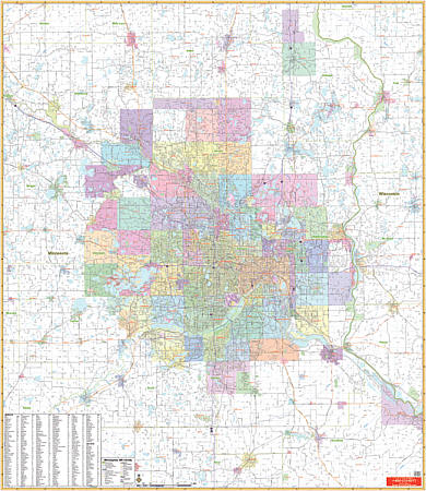
Minneapolis and Vicinity WALL Map.
$249.95
In stock
Scale 1:7,833. Laminated. Printed in color with a markable and washable laminated surface. Cities are indexed on the face of the map. Details include major streets and all highways, ZIP codes and boundaries, latitude and longitude lines, county lines and names, parks, golf courses, amusement centers and stadiums, water features, government buildings and federal penitentiaries, military institutions and airports, hospitals and cemeteries, and mileage circles. Boundaries include Foley, MN and Trade River, WS to the north; extend south to Montgomery, MN and Northfield, MN; include River Falls, WS and Red Wing, MN to the east, and extend west to Winsted, MN and Clear Water, MN. Railed wall maps can be turned into a pull down map on spring rollers for an additional $40.
Scale 1:7,833. Laminated. Printed in color with a markable and washable laminated surface. Cities are indexed on the face of the map. Details include major streets and all highways, ZIP codes and boundaries, latitude and longitude lines, county lines and names, parks, golf courses, amusement centers and stadiums, water features, government buildings and federal penitentiaries, military institutions and airports, hospitals and cemeteries, and mileage circles. Boundaries include Foley, MN and Trade River, WS to the north; extend south to Montgomery, MN and Northfield, MN; include River Falls, WS and Red Wing, MN to the east, and extend west to Winsted, MN and Clear Water, MN. Railed wall maps can be turned into a pull down map on spring rollers for an additional $40.
| Item Price | $249.95 + $24.80 p&h (add $40 for spring rollers) |
|---|
Write Your Own Review