
Newport Harbor Road and Recreation Map, California, America.
$12.95
In stock
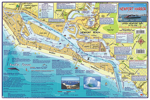
Scale 1:15,000. Size 12"x18". Franko maps edition. Laminated. Side 1 of this map shows Newport Harbor and Side 2 shows Upper Newport Bay. Newport Harbor is depicted in beautiful full color and digitally generated shaded relief, with Newport Beach and Balboa Beach along the Balboa Peninsula, as well as Corona Del Mar State Beach. Side 1 also gives slips, moorings and marinas info, and details of where absolutely everything is located, from popular surfing and diving on the outer waters, to the Balboa Island Ferry, Lido Isle, and Balboa Island within Newport Harbor.
The Upper Newport Bay side, is chalk full of fantastic information about the bay and its Ecological Reserve, its Nature Preserve, The Upper Newport Bay - Peter and Mary Muth Interpretive Center, Big Canyon, The Marine Studies Center at Shellmaker Island, Newport Dunes Resort, the Environmental Nature Center, and North Star Beach, home of the Newport Aquatic Center.
Franko's Maps produces recreation maps for the land and water of selected tourist destinations. The maps are all printed on plasticized paper so they are water resistant.
| Item Price | $12.95 |
|---|
Write Your Own Review