
$249.95
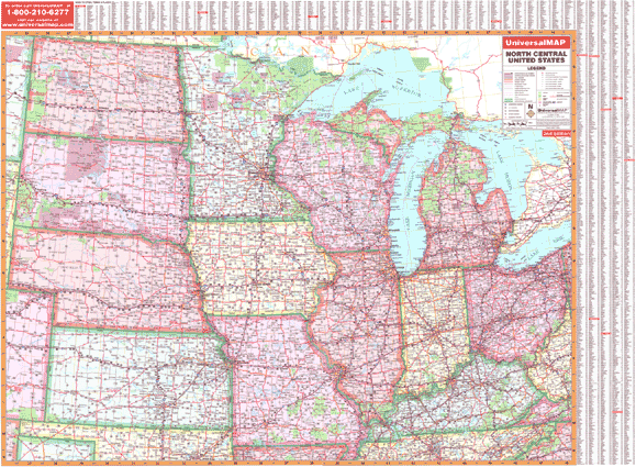
Size 69" W x 49" H. Laminated. The 3rd Edition North Central United States Wall Map by Universal Map shows all of the following states: Illinois, Indiana, Iowa, Kansas, Kentucky, Michigan, Minnesota, Missouri, Nebraska, North Dakota, Ohio, South Dakota, and Wisconsin. There is partial coverage of the following: Northern Tennessee, Northern Oklahoma, and Eastern Colorado. The boundaries are as follows: North: the Canadian border; South: to show the northern portion of Oklahoma, including the city of Tulsa; Texas; Arkansas; and Tennessee--including the cities of Nashville and Knoxville; East: to the western border of Pennsylvania; Beckley, WV; Brampton, CN; West: to include eastern border of Montana down to western border of Oklahoma. The special features and data are as follows: state highways, time zones, interstate highways, rivers and lakes, freeways, national forests, state lines, mountain ranges, longitude and latitude lines and cities and towns. Protected with a laminate finish, which is both markable and washable. In addition, for your convenience, indexing is located on the face of the face of the map. Framing rails are included on top and bottom for easy wall mounting. Railed wall maps can be turned into pull down maps on spring rollers for an additional $40.
Write Your Own Review