
$249.95
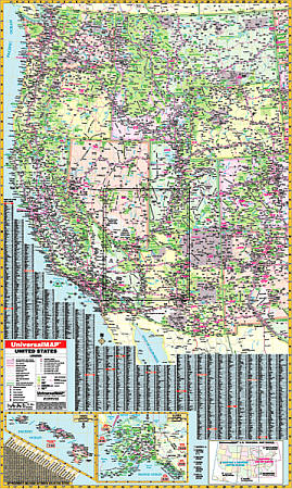
Size 50" W x 68" H. Laminated. The 3rd Edition Western United States Wall Map by Universal Map features all of the following states: Alaska, Arizona, California, Colorado, Hawaii, Idaho, Kansas, Montana, Nebraska, Nevada, New Mexico, North Dakota, Oklahoma, Oregon, South Dakota, Texas, Utah, Washington and Wyoming. The boundaries are as follows: North: Vancouver Island to Winnipeg; South: To Northern Mexico; East: Duluth, Minnesota to Little Rock, Arkansas and Waterloo, Iowa; West: to the Pacific Ocean. Also includes insets of Alaska and Hawaii. The special features and data are as follows: State Highways, Time Zones, Interstate Highways, Rivers and Lakes, Freeways, National Forests, State Lines, Mountain Ranges, Longitude and Latitude Lines, Cities and Towns. This wall map is protected with a laminate finish, which is both markable and washable. In addition, for your convenience, the map is indexed on the face of the face of the map. Framing rails are included on top and bottom for easy wall mounting. Railed wall maps can be turned into pull down maps on spring rollers for an additional $40.
Write Your Own Review