
$229.95
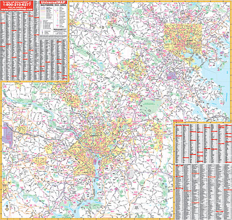
Scale 1:4,950. Size 56" W x 54" H. Laminated. Printed in color with a markable/washable-laminated surface. Streets are indexed on the face of the map. Provided with hanging rails mounted top and bottom. Area of coverage: North: to Lock Raven Reservoir, Kingsville, Pot Spring, and Louisville; South: Lower Marlboro, Mattawoman, Strawberry Hills, Dale City; East: Chesapeake Bay, Martin State Airport, Upper Falls; West: Mt. Airy, Dulles International Airport, Manassas. Features indices of major streets, cities, towns, and points of interest. Details interstate/state/federal highways, county roads, shopping centers, military installations, airports, water features, parks and national forests, hospitals, recreation areas, colleges, and points of interest. Railed wall maps can be turned into pull down maps on spring rollers for an additional $40.
Write Your Own Review