
$249.95
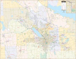
Scale 1:3,128. Size 58" W x 67" H. Laminated. Printed in color with a markable/washable-laminated surface. Streets are indexed in a separate book. Hanging rails mounted top and bottom. Area of coverage: North: to the Oswego County line; South: to the Cortland County line; East: to Cazenovia and Chittenango in Madison County; West: to the Cayuga County line. Includes insets of Downtown Syracuse and Syracuse University and the cities of Auburn, Fulton, and Oswego. Details include all streets and highways, government buildings, airports, water features, fire/police stations, hospitals, shopping centers, educational facilities, railroads, recreational parks, golf/country clubs, post offices, city limits/annexations, ZIP codes/boundaries, cemeteries, and points of interest. Railed wall maps can be turned into pull down maps on spring rollers for an additional $40.
Write Your Own Review