
$249.95
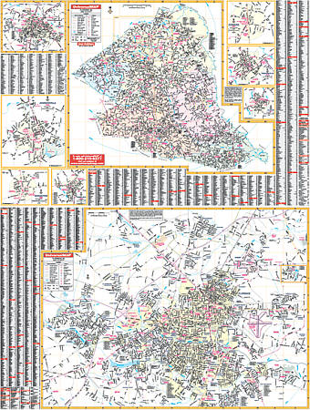
Size 48" W x 72" H. Laminated. The Florence/Florence County, South Carolina Wall Map and adjacent areas by Universal Map includes approximately 600 new streets and changes. Shows complete street detail with boundaries north to the Darlington County line; south to the Williamsburg County line; east to the Marion County line; and west to the Lee and Darlington County lines. The upper half of the map shows the entire county and the lower half shows Florence with insets of Pamplico, Scranton, Johnsonville, Lake City, Coward, Olanta, and Timmonsville. Features all streets/highways, government buildings, airports, golf courses/country clubs, railroads, longitude/latitude lines, zip codes/boundaries, shopping centers, recreational parks, mileage circles, cemeteries, educational facilities, hospitals, post offices, city limits and annexations, fire/police stations, and more. This is lithographed in 8 colors, laminated, indexed on the face of the map, and includes framing rails on top and bottom for easy wall mounting. Railed wall maps can be turned into pull down maps on spring rollers for an additional $40.
Write Your Own Review