
$249.95
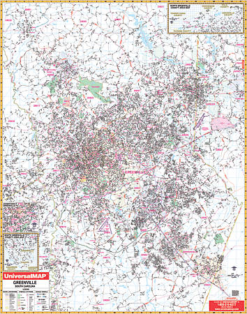
Size 54" W x 70" H. Laminated. The Greenville, South Carolina Wall Map by Universal Map provides a laminated surface that is both markable and washable. Includes up-to-date cartography, complete street detail. Indexing is in a separate book. The area of coverage ranges: North: to include Slater and Marietta; South: to include Fountain Inn and Pelzer; East: to include the BMW Plant and the Greenville-Spartanburg Regional Airport; West: to the Pickens County line. Downtown Greenville, southern Greenville, and northern Greenville County have been added to the map as insets. Residential streets have been added to the county insets. Other details include: airports, all streets and highways, post offices, hospitals, railroads, mileage circles, fire district lines, airports, cemeteries, shopping centers, water features, recreational parks, longitude and latitude lines, government buildings, fire and police stations, educational facilities, golf courses, country clubs, zip codes, zip code boundaries, city limits, annexations, and other points of interest. Framing rails are included on top and bottom for easy wall mounting. Railed wall maps can be turned into pull down maps on spring rollers for an additional $40.
Write Your Own Review