
$249.95
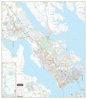
Size 77" W x 54" H. Laminated. The 3rd edition Virginia Peninsula Wall Map by Universal Map offers complete street detail, up-to-date cartography, color, and lamination. Lamination allows the map to be marked on and wiped off easily. The area of coverage runs: North: to the James City County line; South: to include the northern-most point of Norfolk (ties to Universal Map's Tidewater map); East: to the Atlantic Ocean; West: to the James River. Insets provided are to the Governor's Land at Two Rivers and Gloucester Point. The special features and data are as follows: all streets, all highways, educational facilities, government buildings, shopping centers, hospitals, airports, recreational parks, post offices, golf and country clubs, points of interest, city limits and annexations, railroads, mileage circles, water features, cemeteries, fire and police stations, ZIP code and boundaries. In addition, for your convenience, the map is indexed in a separate book. Framing rails are included on top and bottom for easy wall mounting. Railed wall maps can be turned into pull down maps on spring rollers for an additional $40.
Write Your Own Review