
$13.95
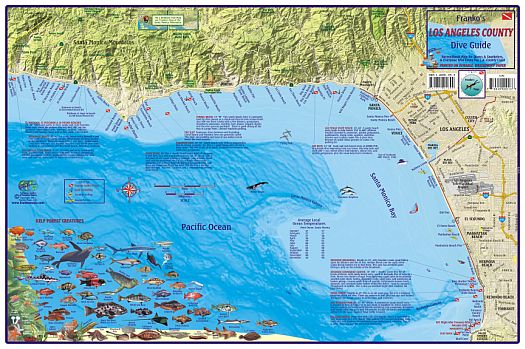
"Various scales". Size 14"x21". Franko maps edition. Laminated. Franko's Dive Map of the Los Angeles County Coast is a recreational map for scuba divers, snorkelers, beach lovers, kayakers, boaters, and all coast explorers. Shows dive sites and beach tourist information from Leo Carrillo State Beach to the Los Angeles Harbor, including Santa Monica Bay, Point Dume, Redondo Beach State Park, and Palos Verdes. Detail of the Palos Verdes peninsula is on the reverse side. Map includes beautiful, accurate drawings of kelp forest sealife and an inset of San Pedro Bay.
Franko's Maps produces recreation maps for the land and water of selected tourist destinations. The maps are all printed on plasticized paper so they are water resistant.
Write Your Own Review