
$14.95
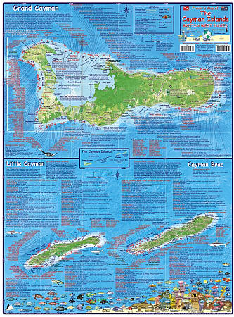
Various scales. Size 19"x26". English text and legends. Lots of useful travel information. Laminated. The front side of the map shows Grand Cayman as a separate map, and the Sister Islands, Little Cayman and Cayman Brac, together as another map. Every detail of the coast can be clearly seen, along with a unique depiction of the bathymetry (underwater topography), so the viewer can visualize how the waters just beyond each island’s shore plunges into the deep. There are over 150 dive sites shown just on Grand Cayman, and then well over 50 more on each of the Sister Islands.
The reverse side of the map shows the west end of Grand Cayman in detail. Numerous captions detail the West End of Grand Cayman, which is the area that probably 90% of all Cayman Islands visitors see. This includes George Town, the capital of The Cayman Islands, and the main city with the most residents. It also details the fabulous Seven Mile Beach area, with every resort and hotel shown as if you are a mile above the Seven Mile Beach looking down on it. You can also see details like where shopping areas are, as well as a few favorite restaurants.
Franko's Maps produces recreation maps for the land and water of selected tourist destinations. The maps are all printed on plasticized paper so they are water resistant.
Write Your Own Review