
$17.95
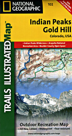
Scale 1:41,000. Size 22"x32". The Indian Peaks/Gold Hill Trails Illustrated map is the most comprehensive recreational map for the southern gateway forests and wilderness areas surrounding Rocky Mountain National Park in Colorado.
Coverage includes Roosevelt and Arapaho national forests, Indian Peaks Wilderness, Arapaho National Recreation Area, Devils Thumb cross-country ski area, Tabernash, Fraser, Nederland, Eldora, Ward, Peaceful Valley, Lake Granby, Barker and Beaver reservoirs, Pawnee, Arapaho and Rollins passes.
Write Your Own Review