
$249.95
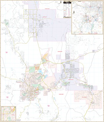
Our Prescott, AZ Wall Map, with adjacent areas, measures 60" x 68" (5' W x 5'8" H) and features up-to-date cartography, with new streets and changes in complete street detail; is printed in color, with a markable and washable laminated surface; and offers a street index in a separate book-format.
The area of coverage includes the following boundaries:
- North to Road 6 North in Chino Valley
- South to Community of Walker and Poland Junction
- East to Dewey-Humboldt and Prescott Valley
- West to Talking Rock Golf Club and the Community of Highland Park
The Prescott, AZ Wall Map also includes inset maps of Yavapai County and Downtown Prescott.
Details and features include:
- AIRPORTS
- BLOCK NUMBERS
- CEMETERIES
- CITY LIMITS
- COMMUNITY NAMES
- EDUCATIONAL INSTITUTIONS
- FIRE & POLICE STATIONS
- GOLF & COUNTRY CLUBS
- GOVERNMENT BUILDINGS
- HOSPITALS
- POINTS OF INTEREST
- POST OFFICES
- RAILROADS
- RECREATIONAL PARKS
- SHOPPING CENTERS
- STREETS & HIGHWAYS
- WATER FEATURES
- ZIP CODE BOUNDARIES
Framing rails are included, top and bottom, for easy wall mounting. Spring roller mounting is also available, for an additional $40.
Write Your Own Review