
$249.95
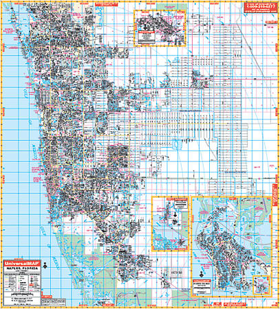
Scale 1:2,560. Size 54" W x 60" H. Laminated. Printed in color with a markable/washable--laminated surface. Street indexed in a separate book. Framing rails are included on top and bottom for easy wall mounting. Railed wall maps can be turned into pull down maps on spring rollers for an additional $40. Area of coverage--all of Naples, with the following boundaries: North: 5 miles into Lee County, including Bonita Springs up to Bonita Bill St.; South: Marco Island airport; East: 14 miles east of SR951 to include the Orangetree Subdivision and Golden Gate Estates, as well as 3 miles east of DeSoto Blvd.; West: to the Gulf of Mexico. Insets: Everglades City, Marco Island, and Immokalee. Special feature: enlarged Marco Island inset, identifying all condominium complexes by name. Details include all streets and highways, government buildings, airports, water features, fire/police stations, hospitals, shopping centers, educational facilities, railroads, recreational parks, golf/country clubs, post offices, city limits/annexations, section/township/range lines, cemeteries, longitude & latitude, ZIP codes/boundaries, and points of interest.
Write Your Own Review