
$17.95
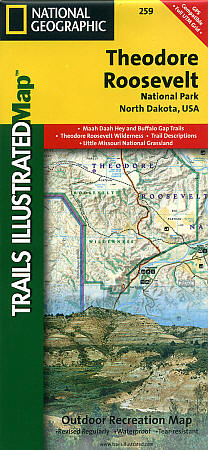
Scale 1:40,000. Size 25"x37". Trails Illustrated edition. Printed on waterproof, tear-resistant, lightweight, paper-like plastic. This Trails Illustrated topographic map is the most comprehensive recreational map for North Dakota's Theodore Roosevelt National Park and the 96-mile Maah Daah Hey Trail.
This two-sided map includes both the north and south units of Theodore Roosevelt National Park, as well as the Magpie and Elkhorn section of the Little Missouri Grassland. In the North Unit of the park, the map includes the Maah Daah Hey Trail, Little Mo Nature Trail, Caprock Coulee Nature Trail, Juniper camping area, and more. The Maah Daah Hey Trail winds south through the Little Missouri National Grassland, meeting Bennett Trail, passes into Magpie, then Elkhorn, then into the South Unit of Theodore Roosevelt National Park.
Map features in the South Unit include Ridgeline Nature Trail, Wind Canyon Trail, the Petrified Forest, Buffalo Gap Trail, Roundup Horse Camp, Cottonwood, Painted Canyon, Sully Creek State Park, the town of Medora, and much more. Includes UTM tick marks for use with your GPS unit.
Write Your Own Review