
$17.95
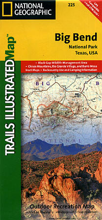
Scale 1:133,000. Size 25"x37". Trails Illustrated edition. Printed on waterproof, tear-resistant, lightweight, paper-like plastic. This Trails Illustrated topographic map is the most comprehensive recreational map for Big Bend National Park, which sits along the border of Texas and Mexico. The map includes Big Bend National Park, Portions of Big Bend Ranch State Park, Black Gap Wildlife Management Area, the Chisos Mountains, Sierra del Carmen, and Sierra del Caballo Muerto. Includes UTM tick marks for use with your GPS unit.
Write Your Own Review