
St. Louis Vicinity WALL Map.
$249.95
In stock
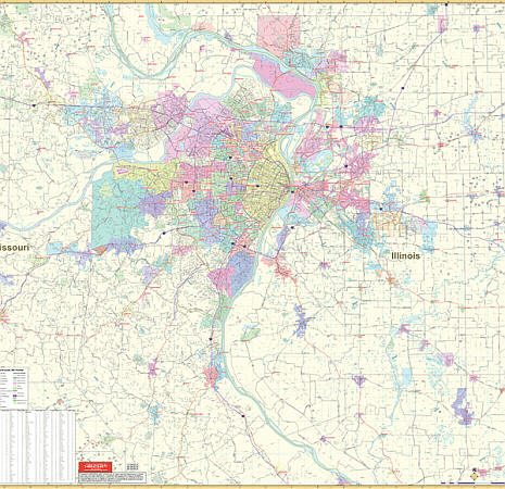
Scale 1:7,400. Size 57" W x 54" H. Laminated. Printed in Color with a markable and washable laminated surface. Cities are indexed on the face of the map. Has mounting rails on top and bottom for ease in hanging. The area of coverage includes urban and suburban St. Louis with all of St. Louis, Jefferson, and St. Charles Counties with portions of Franklin and Lincoln Counties in Missouri, all of Madison, St. Clair and Monroe Counties, portions of Randolph, Washington, and Clinton Counties in Illinois. Ranges: North: 25 miles North to Godfrey and Staunton; South: 45 miles South to Sparta, DeSoto, Bloomsdale; East: 35 miles East to Illinois; Highland, Aviston, Damiansville; West: 40 miles to Fortstell, Union, St. Clair Parkway, Villa Ridge. Details include all major streets and highways, county lines and names, mileage circles, ZIP codes and boundaries, airports and parks, water features, and longitude/latitude lines. Railed wall maps can be turned into pull down maps on spring rollers for an additional $40.
Scale 1:7,400. Size 57" W x 54" H. Laminated. Printed in Color with a markable and washable laminated surface. Cities are indexed on the face of the map. Has mounting rails on top and bottom for ease in hanging. The area of coverage includes urban and suburban St. Louis with all of St. Louis, Jefferson, and St. Charles Counties with portions of Franklin and Lincoln Counties in Missouri, all of Madison, St. Clair and Monroe Counties, portions of Randolph, Washington, and Clinton Counties in Illinois. Ranges: North: 25 miles North to Godfrey and Staunton; South: 45 miles South to Sparta, DeSoto, Bloomsdale; East: 35 miles East to Illinois; Highland, Aviston, Damiansville; West: 40 miles to Fortstell, Union, St. Clair Parkway, Villa Ridge. Details include all major streets and highways, county lines and names, mileage circles, ZIP codes and boundaries, airports and parks, water features, and longitude/latitude lines. Railed wall maps can be turned into pull down maps on spring rollers for an additional $40.
| Item Price | $249.95 + $24.80 p&h (add $40 for spring rollers) |
|---|
Write Your Own Review