
Summit, Vail, and Holy Cross Hiking Map.
$12.95
In stock
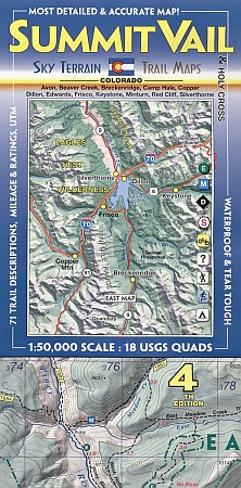
Scale 1:50,000. Sky Terrain edition. Excellent map covers a total of 18 USGS quad maps (9 on each side). Areas of note include the TenMile Range, Boreas Pass, Breckenidge, Frisco, Quandary Peak, the Colorado Trail, Copper Mountain, Vail, Beaver Creek, Minturn, Red Cliff, Eagle River, Gore Creek, Dillon, Silverthorne, Avon, Edwards, Mount of the Holy Cross, Camp Hale, Jacque Peak, Searle Pass, French Pass, Loveland Pass, Keystone and much, much more.
Scale 1:50,000. Sky Terrain edition. Excellent map covers a total of 18 USGS quad maps (9 on each side). Areas of note include the TenMile Range, Boreas Pass, Breckenidge, Frisco, Quandary Peak, the Colorado Trail, Copper Mountain, Vail, Beaver Creek, Minturn, Red Cliff, Eagle River, Gore Creek, Dillon, Silverthorne, Avon, Edwards, Mount of the Holy Cross, Camp Hale, Jacque Peak, Searle Pass, French Pass, Loveland Pass, Keystone and much, much more.
| Item Price | $12.95 |
|---|
Write Your Own Review