
Worcester, Massachusetts, America.
$249.95
In stock
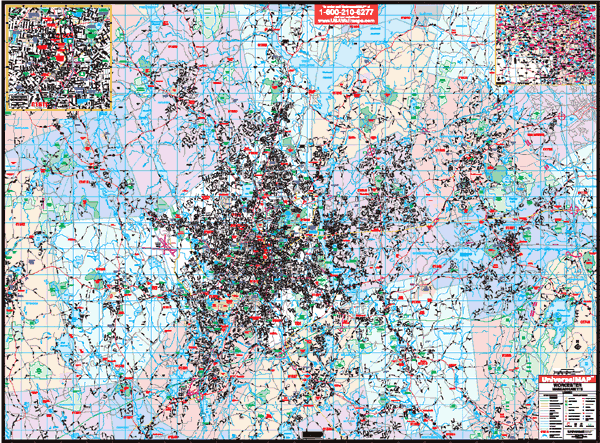
Scale 1:1,802. Size 69" W x 54" H. Laminated.. Provides up-to-date cartography with all new streets and changes. Printed in color with a markable/washable-laminated surface. Streets indexed in a separate book. Contains hanging rails mounted top and bottom. Covers Auburn, Grafton, Holden, Leicester, Northborough, Millbury, Paxton, West Boylston, Boylston, Westborough, and Worcester. Boundaries: North: Trout Brook, Conservation Area and all of West Boylston; South: all of Auburn to Oxford city limit, Sutton includes Singletary Lake and West Upton; East: to I-495 and a portion of Hopkinton; West: portion of Spencer and Paxton Falls. Includes a Downtown, Worcester; Worcester/Boston area map. Details include all state highways, government buildings, airports, water features, fire/police stations, hospitals, shopping centers, educational facilities, railroads, recreational parks, golf/country clubs, post offices, city limits/annexations, cemeteries, ZIP codes/boundaries, longitude/latitude, mileage circles, and points of interest. Railed wall maps can be turned into pull down maps on spring rollers for an additional $40.
Scale 1:1,802. Size 69" W x 54" H. Laminated.. Provides up-to-date cartography with all new streets and changes. Printed in color with a markable/washable-laminated surface. Streets indexed in a separate book. Contains hanging rails mounted top and bottom. Covers Auburn, Grafton, Holden, Leicester, Northborough, Millbury, Paxton, West Boylston, Boylston, Westborough, and Worcester. Boundaries: North: Trout Brook, Conservation Area and all of West Boylston; South: all of Auburn to Oxford city limit, Sutton includes Singletary Lake and West Upton; East: to I-495 and a portion of Hopkinton; West: portion of Spencer and Paxton Falls. Includes a Downtown, Worcester; Worcester/Boston area map. Details include all state highways, government buildings, airports, water features, fire/police stations, hospitals, shopping centers, educational facilities, railroads, recreational parks, golf/country clubs, post offices, city limits/annexations, cemeteries, ZIP codes/boundaries, longitude/latitude, mileage circles, and points of interest. Railed wall maps can be turned into pull down maps on spring rollers for an additional $40.
| Item Price | $249.95 + $24.80 p&h (add $40 for spring rollers) |
|---|
Write Your Own Review