
Asheville Vicinity WALL Map, North Carolina, America.
$229.95
In stock
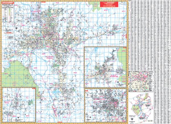
Scale 1:166,000. Size 66" W x 54" H. Laminated. Printed in color with a markable/washable-laminated surface. Cities and towns are indexed on the face of the map. Hanging rails mounted top and bottom. The area of coverage includes the counties of Avery, Buncombe, Haywood, Henderson, Madison, McDowell Mitchell, Rutherford, Yancey, and portions of Burlee, Carter, Jackson, Transylvania, and Watauge in North Carolina. In Tennessee find Cocke, Greene, Unicoi, and portions of Washington, Hawkins, Hamblen, Jefferson, and Sevier. Covers: North: 55 miles north including Johnson City, Tennessee; South: 30 miles south to Brevard in Transylvania County; West: 60 miles west including Pigeon Forge and Sevierville in Tennessee; East: 50 miles east including Morgantown in Burke County. Details major streets and all highways, county lines and names, mileage circles, ZIP codes and boundaries, airports and parks, water features, and longitude/latitude lines. Railed wall maps can be turned into pull down maps on spring rollers for an additional $40.
Scale 1:166,000. Size 66" W x 54" H. Laminated. Printed in color with a markable/washable-laminated surface. Cities and towns are indexed on the face of the map. Hanging rails mounted top and bottom. The area of coverage includes the counties of Avery, Buncombe, Haywood, Henderson, Madison, McDowell Mitchell, Rutherford, Yancey, and portions of Burlee, Carter, Jackson, Transylvania, and Watauge in North Carolina. In Tennessee find Cocke, Greene, Unicoi, and portions of Washington, Hawkins, Hamblen, Jefferson, and Sevier. Covers: North: 55 miles north including Johnson City, Tennessee; South: 30 miles south to Brevard in Transylvania County; West: 60 miles west including Pigeon Forge and Sevierville in Tennessee; East: 50 miles east including Morgantown in Burke County. Details major streets and all highways, county lines and names, mileage circles, ZIP codes and boundaries, airports and parks, water features, and longitude/latitude lines. Railed wall maps can be turned into pull down maps on spring rollers for an additional $40.
| Item Price | $229.95 + $24.80 p&h (add $40 for spring rollers) |
|---|
Write Your Own Review