
Asheville WALL Map, North Carolina, America.
$229.95
In stock
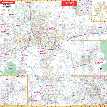
Scale 1:166,000. Size 73" W x 54" H. Laminated. The Asheville, North Carolina Wall Map by Universal Map. Printed in color with a laminated surface making it both markable and washable. Street indexing appears on the face of the map. The area of coverage ranges: North: to the City of Woodfin; South: to the Asheville Municipal Airport; East: Asheville city limits and Grovemont (continues on inset); West: to the Asheville city limit and Enka Lake. Insets: Weaverville, Black Mountain, Montreat, Buncombe County, Hendersonville, and Downtown Asheville. Includes all streets, hospitals, cemeteries, water features, mileage circles, post offices, shopping centers, airports and railroads, golf courses and country clubs, longitude and latitude lines, government buildings, fire and police stations, educational facilities, recreational parks, ZIP codes and their boundaries. Framing rails are included on top and bottom for easy wall mounting. Railed wall maps can be turned into pull down maps on spring rollers for an additional $40.
Scale 1:166,000. Size 73" W x 54" H. Laminated. The Asheville, North Carolina Wall Map by Universal Map. Printed in color with a laminated surface making it both markable and washable. Street indexing appears on the face of the map. The area of coverage ranges: North: to the City of Woodfin; South: to the Asheville Municipal Airport; East: Asheville city limits and Grovemont (continues on inset); West: to the Asheville city limit and Enka Lake. Insets: Weaverville, Black Mountain, Montreat, Buncombe County, Hendersonville, and Downtown Asheville. Includes all streets, hospitals, cemeteries, water features, mileage circles, post offices, shopping centers, airports and railroads, golf courses and country clubs, longitude and latitude lines, government buildings, fire and police stations, educational facilities, recreational parks, ZIP codes and their boundaries. Framing rails are included on top and bottom for easy wall mounting. Railed wall maps can be turned into pull down maps on spring rollers for an additional $40.
| Item Price | $229.95 + $24.80 p&h (add $40 for spring rollers) |
|---|
Write Your Own Review