
Canada, East, Adventure Road and Tourist Map,Canada.
$16.95
In stock
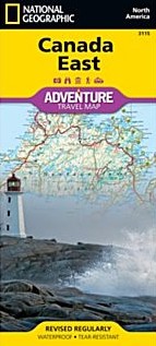
Scale 1:2,100,000. Size 26"x38". National Geographic edition. National Geographic's Canada East Adventure Map is designed to meet the unique needs of adventure travelers with its durability and accurate information. Each folded map provides global travelers with the perfect combination of detail and perspective, highlighting the area’s terrain and best locations for adventure activities like snorkeling, surfing, fishing, and more. Adventure Maps include hundreds of points of interest that highlight diverse and unique destinations within the country.
The map includes the locations of thousands of cities and towns with a user-friendly index, plus a clearly marked road network complete with distances and designations for major highways, main roads, and tracks and trails for those seeking to explore more remote regions.
Key Features:
Waterproof and tear-resistant
Detailed interpretive information and local travel tips
Detailed topography complete with activity symbols, ideal for exploring the country
City overview maps
Hundreds of points of interest, including the location of World Heritage sites, national parks and nature reserves, aboriginal settlements and protected lands, mines, archeological sites, wildlife parks and more
Thousands of place names
Important travel aids including airports, lighthouses, ferry routes and rail lines
Developed in cooperation with local agencies
Updated regularly to ensure accuracy
Printed in the U.S.
| Item Price | $16.95 |
|---|
Write Your Own Review