
Charleston Vicinity WALL Map, South Carolina, America.
$249.95
In stock
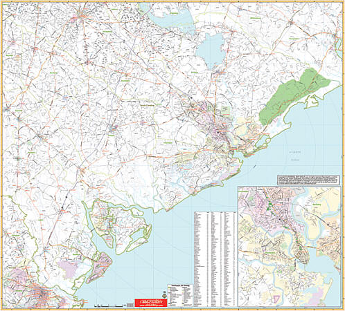
Scale 1:210,000. Size 60" W x 54" H. Laminated. Printed in color with a markable/washable--laminated surface. Cities and towns are indexed on the face of the map. Includes hanging rails mounted top and bottom. Area of coverage: All of the following 8 counties: Bamberg, Berkeley, Beaufort, Charleston, Colleton, Dorchester, Hampton, and Jasper. Portions of the following 7 counties: Allendale, Barnwell, Chatham, GA, Effingham, GA, Georgetown, Orangeburg, and Williams. Boundaries: North: 50 miles from Charleston, to include Land and Orangeburg, SC; South: 55 miles from Charleston, to include Savannah, GA; East: 120 miles of coastline from Tybee Island, GA to McClellanville, and including Georgetown; West: 80 miles from Charleston, to include Blackville and Allendale, SC. Details include major streets and highways, ZIP codes/boundaries, longitude/latitude, military installations, county lines, mileage circles, water features, hospitals, airports, parks, golf courses, and cemeteries. Railed wall maps can be turned into pull down maps on spring rollers for an additional $40.
Scale 1:210,000. Size 60" W x 54" H. Laminated. Printed in color with a markable/washable--laminated surface. Cities and towns are indexed on the face of the map. Includes hanging rails mounted top and bottom. Area of coverage: All of the following 8 counties: Bamberg, Berkeley, Beaufort, Charleston, Colleton, Dorchester, Hampton, and Jasper. Portions of the following 7 counties: Allendale, Barnwell, Chatham, GA, Effingham, GA, Georgetown, Orangeburg, and Williams. Boundaries: North: 50 miles from Charleston, to include Land and Orangeburg, SC; South: 55 miles from Charleston, to include Savannah, GA; East: 120 miles of coastline from Tybee Island, GA to McClellanville, and including Georgetown; West: 80 miles from Charleston, to include Blackville and Allendale, SC. Details include major streets and highways, ZIP codes/boundaries, longitude/latitude, military installations, county lines, mileage circles, water features, hospitals, airports, parks, golf courses, and cemeteries. Railed wall maps can be turned into pull down maps on spring rollers for an additional $40.
| Item Price | $249.95 + $24.80 p&h (add $40 for spring rollers) |
|---|
Write Your Own Review