
Fayetteville WALL Map, North Carolina, America.
$249.95
In stock
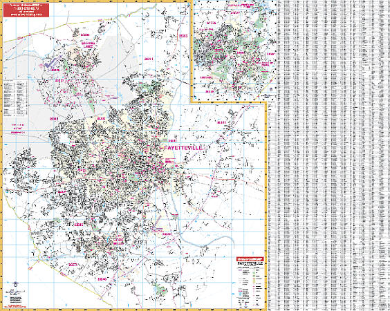
Scale 1:2,650. Size 64" W x 51" H. Laminated. The 3rd Edition Wall Map of Fayetteville, North Carolina with adjacent areas is published by Universal Map. Printed in color with a markable and washable laminated surface. Streets are indexed on the face of the map. Mounted top and bottom with hanging rails. Area of coverage: North: to Harnett-Cumberland County line (North to North Central) and Exit 58 on I-95 at US 13 (Northeast corner), including Spring Lake; South: includes Cypress Lakes Golf Course, 5 miles south of Exit 46 on I-95 along Eizabethtown Road (SR 87), including Hope Mills; East: to 3 ? miles east of Exit 52 on I-95 (along SR24); West: includes Fort Bragg, Cumberland County line crossing US 401. Insets: Southern Pines area, including Aberdeen, Pinehurst, Taylortown, and Whispering Pines. Details include airports, all streets and highways, government buildings, hospitals, shopping centers, fire and police stations, cemeteries, water features, educational facilities, railroads, recreational parks, golf and country clubs, post offices, mileage circles, ZIP codes and boundaries, city limits and annexations, longitude and latitude lines, and points of interest. Railed wall maps can be turned into pull down maps on spring rollers for an additional $40.
Scale 1:2,650. Size 64" W x 51" H. Laminated. The 3rd Edition Wall Map of Fayetteville, North Carolina with adjacent areas is published by Universal Map. Printed in color with a markable and washable laminated surface. Streets are indexed on the face of the map. Mounted top and bottom with hanging rails. Area of coverage: North: to Harnett-Cumberland County line (North to North Central) and Exit 58 on I-95 at US 13 (Northeast corner), including Spring Lake; South: includes Cypress Lakes Golf Course, 5 miles south of Exit 46 on I-95 along Eizabethtown Road (SR 87), including Hope Mills; East: to 3 ? miles east of Exit 52 on I-95 (along SR24); West: includes Fort Bragg, Cumberland County line crossing US 401. Insets: Southern Pines area, including Aberdeen, Pinehurst, Taylortown, and Whispering Pines. Details include airports, all streets and highways, government buildings, hospitals, shopping centers, fire and police stations, cemeteries, water features, educational facilities, railroads, recreational parks, golf and country clubs, post offices, mileage circles, ZIP codes and boundaries, city limits and annexations, longitude and latitude lines, and points of interest. Railed wall maps can be turned into pull down maps on spring rollers for an additional $40.
| Item Price | $249.95 + $24.80 p&h (add $40 for spring rollers) |
|---|
Write Your Own Review