
Flaming Gorge and East Uintas, Road and Recreation Map, Utah, America.
$17.95
In stock
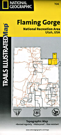
Scale 1:90,000. Size 25"x37". Trails Illustrated edition. Printed on waterproof, tear-resistant, lightweight, paper-like plastic. This Trails Illustrated topographic map is the most comprehensive recreational map for Utah's Flaming Gorge N.R.A/Eastern Uintas area. Coverage includes; Ashley National Forest; Flaming Gorge National Recreation Area; Eastern Uinta Mountains; Steinaker State Recreation Area; Green River, Wyoming; McKinnon Junction, Dutch John, Dry Fork, Manila and Greendale; Matt Warner, Cedar View and Beaver Meadow reservoirs; and the Red Canyon of the Green River.
Scale 1:90,000. Size 25"x37". Trails Illustrated edition. Printed on waterproof, tear-resistant, lightweight, paper-like plastic. This Trails Illustrated topographic map is the most comprehensive recreational map for Utah's Flaming Gorge N.R.A/Eastern Uintas area. Coverage includes; Ashley National Forest; Flaming Gorge National Recreation Area; Eastern Uinta Mountains; Steinaker State Recreation Area; Green River, Wyoming; McKinnon Junction, Dutch John, Dry Fork, Manila and Greendale; Matt Warner, Cedar View and Beaver Meadow reservoirs; and the Red Canyon of the Green River.
| Item Price | $17.95 |
|---|
Write Your Own Review