
Kansas City WALL Map.
$309.95
In stock
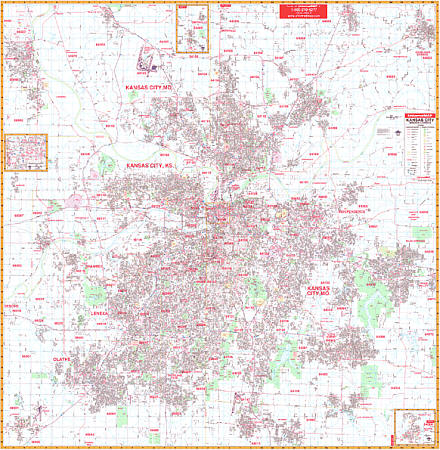
Scale 1:3,206. Size 69" W x 70" H. Laminated. The Kansas City, Missouri and Kansas Wall Map by Universal Map. Printed in color with a markable/washable-laminated surface. Area of coverage: North: to include Platte City, Missouri, and most of Kearney, MO: South: to include Gardner, KS; Belton, MO; and Raymore, MO: East: to the eastern limit of Independence, MO and the Clay/Ray County lines: West: to include Leavenworth, KS; and Gardner, KS. Insets include Pleasant Hill, MO; Smithville, MO; and downtown Kansas City, MO. Features all streets and highways, government buildings, airports, golf courses and country clubs, railroads, ZIP codes and ZIP code boundaries, shopping centers, water features, recreational parks, cemeteries, educational facilities, hospitals, post offices, city limits and annexations, longitude and latitude lines, section/township/range lines, mileage circles, fire and police stations, and miscellaneous points of interest. Framing rails are included on top and bottom for easy wall mounting. Railed wall maps can be turned into pull down maps on spring rollers for an additional $40.
Scale 1:3,206. Size 69" W x 70" H. Laminated. The Kansas City, Missouri and Kansas Wall Map by Universal Map. Printed in color with a markable/washable-laminated surface. Area of coverage: North: to include Platte City, Missouri, and most of Kearney, MO: South: to include Gardner, KS; Belton, MO; and Raymore, MO: East: to the eastern limit of Independence, MO and the Clay/Ray County lines: West: to include Leavenworth, KS; and Gardner, KS. Insets include Pleasant Hill, MO; Smithville, MO; and downtown Kansas City, MO. Features all streets and highways, government buildings, airports, golf courses and country clubs, railroads, ZIP codes and ZIP code boundaries, shopping centers, water features, recreational parks, cemeteries, educational facilities, hospitals, post offices, city limits and annexations, longitude and latitude lines, section/township/range lines, mileage circles, fire and police stations, and miscellaneous points of interest. Framing rails are included on top and bottom for easy wall mounting. Railed wall maps can be turned into pull down maps on spring rollers for an additional $40.
| Item Price | $309.95 + $24.80 p&h (add $40 for spring rollers) |
|---|
Write Your Own Review