
Lake and Geauga County WALL Map, Ohio, America.
$249.95
In stock
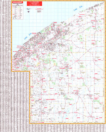
Size 64" W x 54" H. Laminated. The Lake and Geauga Counties, Ohio Wall Map by Universal Map contains up-to-date cartography, complete street detail, lamination, and full-color. Coverage ranges north to Lake Erie; south to the Geauga-Portage County line; east to the Lake-Geauga County Line with Ashtabula and Trumble County lines; and west to the Cuyahoga County Line. Details all streets, post offices, hospitals, railroads, mileage circles, municipal township names/boundaries, airports, cemeteries, shopping centers, water features, recreational parks, government buildings, fire/police stations, educational facilities, golf courses/country clubs, and ZIP codes/boundaries. Framing rails are included on top and bottom for easy wall mounting. Railed wall maps can be turned into pull down maps on spring rollers for an additional $40.
Size 64" W x 54" H. Laminated. The Lake and Geauga Counties, Ohio Wall Map by Universal Map contains up-to-date cartography, complete street detail, lamination, and full-color. Coverage ranges north to Lake Erie; south to the Geauga-Portage County line; east to the Lake-Geauga County Line with Ashtabula and Trumble County lines; and west to the Cuyahoga County Line. Details all streets, post offices, hospitals, railroads, mileage circles, municipal township names/boundaries, airports, cemeteries, shopping centers, water features, recreational parks, government buildings, fire/police stations, educational facilities, golf courses/country clubs, and ZIP codes/boundaries. Framing rails are included on top and bottom for easy wall mounting. Railed wall maps can be turned into pull down maps on spring rollers for an additional $40.
| Item Price | $249.95 + $24.80 p&h (add $40 for spring rollers) |
|---|
Write Your Own Review