
Lansing WALL Map.
$249.95
In stock
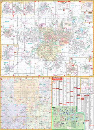
Scale 1:3,120. Size 54" W x 74" H. Laminated. Includes up-to-date cartography with new streets and changes. Printed in color with a markable/washable-laminated surface. Streets indexed in a separate book. Hanging rails mounted top and bottom. Boundaries as follows: North: Includes city of DeWitt; South: Includes the city of Potterville; East: To Meridian Road; West: Includes city of Grand Ledge. Map Insets include: Eaton Rapids, Laingsburg, Grand Ledge, Charlotte, Mason, Perry, Portland, St. Johns, Williamston, Michigan State University and Downtown Lansing. A new addition for this map is a Regional map of Eaton, Ingham, and Clinton Counties with a portion of Ionia and Shiawassee Counties. The special features and data are as follows: all streets, all highways, railroads, educational facilities, hospitals, government buildings, golf and country clubs, ZIP codes and boundaries, post offices, fire/police stations, shopping centers, airports, cemeteries, recreational parks, points of interest, city limits and annexations, water features, railroads, township names, range/twp/section lines, longitude and latitude lines, and block numbers. Railed wall maps can be turned into pull down maps on spring rollers for an additional $40.
Scale 1:3,120. Size 54" W x 74" H. Laminated. Includes up-to-date cartography with new streets and changes. Printed in color with a markable/washable-laminated surface. Streets indexed in a separate book. Hanging rails mounted top and bottom. Boundaries as follows: North: Includes city of DeWitt; South: Includes the city of Potterville; East: To Meridian Road; West: Includes city of Grand Ledge. Map Insets include: Eaton Rapids, Laingsburg, Grand Ledge, Charlotte, Mason, Perry, Portland, St. Johns, Williamston, Michigan State University and Downtown Lansing. A new addition for this map is a Regional map of Eaton, Ingham, and Clinton Counties with a portion of Ionia and Shiawassee Counties. The special features and data are as follows: all streets, all highways, railroads, educational facilities, hospitals, government buildings, golf and country clubs, ZIP codes and boundaries, post offices, fire/police stations, shopping centers, airports, cemeteries, recreational parks, points of interest, city limits and annexations, water features, railroads, township names, range/twp/section lines, longitude and latitude lines, and block numbers. Railed wall maps can be turned into pull down maps on spring rollers for an additional $40.
| Item Price | $249.95 + $24.80 p&h (add $40 for spring rollers) |
|---|
Write Your Own Review