
Los Angeles Vicinity WALL Map California, America.
$229.95
In stock
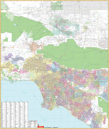
Scale 1:8,341. Size 54" W x 64" H. Laminated. Printed in color with a washable/markable-laminated surface. Has hanging rails mounted top and bottom. Cities are indexed on the face of the map. Area of Coverage: North: to Willow Springs and Lancaster; South: includes Laguna Beach and Mission Viejo; East: to Corona and Ontario; West: includes Fillmore and Malibu. Details include major streets/all highways, ZIP codes/boundaries, latitude/longitude lines, county lines/names, parks/golf course/amusement centers/stadiums, water features, government buildings/federal penitentiaries, military installations/airports, hospitals, cemeteries, mileage circles, and points of interest. Railed wall maps can be turned into pull down maps on spring rollers for an additional $40.
Scale 1:8,341. Size 54" W x 64" H. Laminated. Printed in color with a washable/markable-laminated surface. Has hanging rails mounted top and bottom. Cities are indexed on the face of the map. Area of Coverage: North: to Willow Springs and Lancaster; South: includes Laguna Beach and Mission Viejo; East: to Corona and Ontario; West: includes Fillmore and Malibu. Details include major streets/all highways, ZIP codes/boundaries, latitude/longitude lines, county lines/names, parks/golf course/amusement centers/stadiums, water features, government buildings/federal penitentiaries, military installations/airports, hospitals, cemeteries, mileage circles, and points of interest. Railed wall maps can be turned into pull down maps on spring rollers for an additional $40.
| Item Price | $229.95 + $24.80 p&h (add $40 for spring rollers) |
|---|
Write Your Own Review