
Loudon County WALL Map, Tennessee, America.
$249.95
In stock
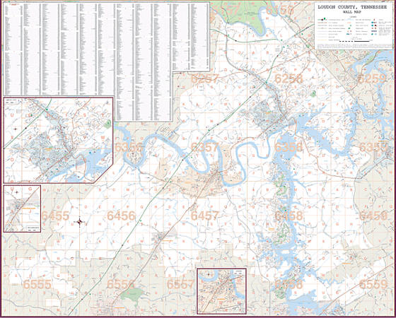
Scale 1:2,640. Size 77" W x 54" H. Laminated. Printed in color with a markable/washable--laminated surface. Street index provided in a separate book. Framing rails are included on top and bottom for easy wall mounting. Railed wall maps can be turned into pull down maps on spring rollers for an additional $40. Area of coverage: All of Loudon County including cities & towns of Loudon & Lenoir City. North: to Anderson & Knox County Line; South: to Monroe County Line; East: to Blount County Line; and West: to Roane County Line. Insets: Downtown Loudon, Lenoir City & Philadelphia. Details include all streets and highways, government buildings, airports, water features, fire/police stations, hospitals, shopping centers, educational institutions, railroads, recreational parks, golf and country clubs, post offices, city limits/annexations, cemeteries, township/range/section lines, block numbers, subdivisions, ZIP codes/boundaries, longitude & latitude, and points of interest.
Scale 1:2,640. Size 77" W x 54" H. Laminated. Printed in color with a markable/washable--laminated surface. Street index provided in a separate book. Framing rails are included on top and bottom for easy wall mounting. Railed wall maps can be turned into pull down maps on spring rollers for an additional $40. Area of coverage: All of Loudon County including cities & towns of Loudon & Lenoir City. North: to Anderson & Knox County Line; South: to Monroe County Line; East: to Blount County Line; and West: to Roane County Line. Insets: Downtown Loudon, Lenoir City & Philadelphia. Details include all streets and highways, government buildings, airports, water features, fire/police stations, hospitals, shopping centers, educational institutions, railroads, recreational parks, golf and country clubs, post offices, city limits/annexations, cemeteries, township/range/section lines, block numbers, subdivisions, ZIP codes/boundaries, longitude & latitude, and points of interest.
| Item Price | $249.95 + $24.80 p&h (add $40 for spring rollers) |
|---|
Write Your Own Review